Western students contribute to a study that could change the game for water in the thirsty West
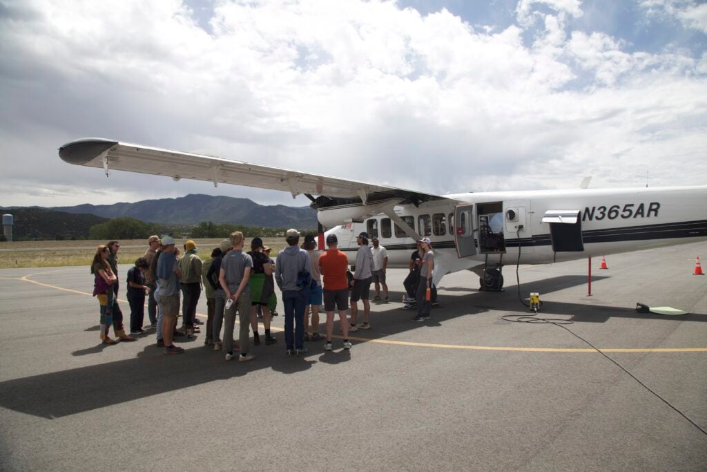
It’s just after 9:30 in the morning, and we’re standing in waist-high wildflowers and meadowgrass on Snodgrass Mountain, staring up into a bright blue sky, searching. Somewhere to the east, the faint hum of an airplane is growing louder, and soon a speck of silver flashes above the Elk Mountains. “There it is,” someone shouts. This is the flight we’ve come for.
The plane and the 20-odd students and researchers on the ground are part of a coordinated effort known as the Colorado Headwaters Ecological Spectroscopy Study (CHESS), funded by NASA, the National Science Foundation, and the Department of Energy. Together, they’ll calibrate an emerging technology called imaging spectroscopy, which could help scientists detect subtle ecological changes and better understand how water, soil, and plants interact in a warming world.
What makes this research so important is that it will allow scientists to see far beyond what the human eye can perceive. While the human eye has three types of cells sensitive to a relatively narrow spectrum of light, imaging spectroscopy uses sensors that pick up 426 different wavelengths, nearly all of them infrared wavelengths outside the visible spectrum.
On the ground, every plant reflects different wavelengths of light in a pattern that changes subtly based on factors like carbon, nitrogen, and water content. By calibrating the light the spectrometer sees with on-the-ground plant data, scientists can get valuable information about the plants and the health of the larger ecosystem.
“If a leaf has less moisture, it will reflect more energy in the shortwave infrared. That relationship is pretty well established. But you have to calibrate it for a given site and a given ecosystem,” Dr. Ian Breckheimer, a landscape ecologist at Rocky Mountain Biological Laboratory (RMBL) and Western, said. “So we’re building up relationships between what we can measure on the ground and how those same leaves interact with light that’s detectable from the airplane.”
If everything goes according to plan, the imaging technology will be deployed aboard a NASA satellite sometime in the next five or six years. But first, a team of scientists has to ensure that what the spectrometer sees matches what’s actually on the ground. That’s where students and researchers from Western Colorado University, Rocky Mountain Biological Laboratory (RMBL), and the Lawrence Berkeley National Laboratory step in to help.

Ground truthing at 10,000 feet
It’s a Saturday when the weather provides a cloudless window for the flight to take place. Because of the equipment’s sensitivity, any particles in the atmosphere, from water vapor to wildfire smoke, could cause anomalies in the data that make it hard to read. But the sky is an unblemished deep blue.
The team arrives before most of the morning’s hikers have made their way to the trailhead. Despite being Crested Butte’s second most accessible mountain playground, Snodgrass is also within RMBL’s research zone, where top-tier scientists from around the country spread out every summer to start or resume their studies on the area’s ecology.


The meadow where students take the ground and near-ground measurements isn’t far below the summit, and requires an uphill hike through aspen and spruce forests to reach. There, four teams mobilize to study trees, meadow plants, soil, and shrubs. In addition to getting as many physical measurements as possible, they’ll also collect samples to be analyzed in a lab for chemical makeup and water content. But it’s the high-tech component that makes this outing unique.
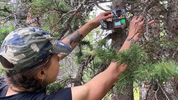
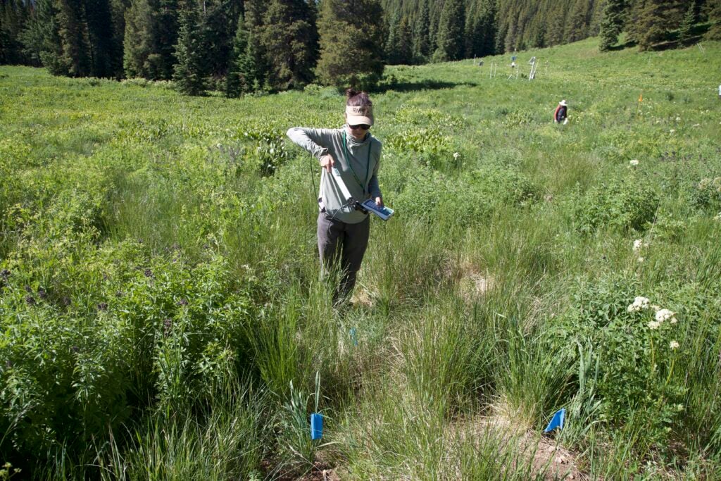
Throughout the meadow, researchers pass a specialized wand near the ground to measure the wavelengths of light the soils and plants reflect. Several Western students and Professor Jonathan Coop are with the rest of the Tree Team gathering data and clippings from 18 trees – 14 conifers and four aspen – near the meadow. They also use a GPS receiver to record each tree’s location and a Terrestrial Laser Scanning LiDAR sensor, which uses lasers in a way similar to how SONAR uses sound, to build a near-perfect three-dimensional map of the forest canopy’s underside.
In the middle of the meadow, Western graduate student Bradley Sowder is preparing a camera-carrying drone that he programmed to fly back and forth 300 feet above the ground in parallel lines 80 feet apart to build detailed imagery and 3D models of the surrounding landscape. “The grid lines will have 85 percent overlap,” he said, “so when you stitch it all together, it creates this really comprehensive analysis.”
A high-level view
The airplane the researchers on the ground are scheduled to meet is operated by the National Ecological Observatory Network (NEON), which periodically flies over more than 80 field sites around the United States and is funded by the NSF to provide standardized, open-access ecological data for scientists to use in their research. The last time NEON flights flew over the study area was in 2018.
To get the images they need today, the crew of four flies the plane, with $6 million in sensors and computer equipment aboard, low, at around 3,000 feet above the ground, and relatively slow, sometimes less than 100 miles per hour, for up to four hours in a precise pattern.
The wavelength data collected by the plane’s spectrometer, along with data from the LiDAR scanner and high-resolution camera, can produce an image of the ground below with a 1-meter resolution. Meanwhile, the drone collects imaging data at 2cm to 3cm resolution, and data from the wand, collected at ground level, provides an incredibly precise leaf-level view of the wavelengths of light being reflected.
Once the terabytes of data from the study have been analyzed, in about 2 or 3 months, they’ll be compared, pixel by pixel, to the more than 800 plant and soil samples that were collected over six weeks on the ground.
Taken together, the data collected during NEON flights in 2018 and 2025 will provide an unprecedented picture of how water moves from soil and plants into the river system and how that changes over time.
Western’s role in the CHESS project is essential and a testament to the University’s growing involvement in high-impact environmental research. Students aren’t just learning about climate and water challenges; they’re shaping the tools scientists will use to address them. And as technology and environmental models evolve, the work that began here will help guide policy decisions affecting millions of people.
“The plant traits that the spectrometer can see are strongly related to how much water plants pull out of the soil and how well they can continue to do that as soils get dry,” Breckheimer said. “This is a critical missing piece in models of the hydrology of the Colorado River Basin. Better models will lead to better streamflow forecasts and, hopefully, more efficient use of water by farmers and municipalities.”
The project’s undergraduate research was funded through a $720,000 grant from the Department of Energy’s RENEW initiative.